Alaska Arctic Toposequence Examples
- AATVM
- Vegetation
- Bioclimate Subzones
- Floristic Provinces
- AVHRR
- Elevation
- Lake Cover
- Physiography
- NDVI and Phytomass
- Substrate Chemistry
- Literature
Examples from the literature for northern Alaska:
Toposequences have been used to conceptualize the natural vegetation variation of four key vegetation and soil studies in northern Alaska:
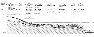
- at Prudhoe Bay (Fig. 2)
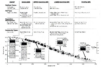
- Imnavait Creek (Fig. 3)
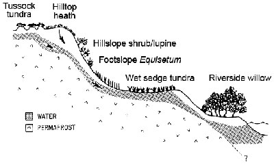
- a river terrace of the Sagavanirktok River (Fig. 4)
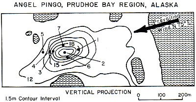
- pingos of the central Arctic Coastal Plain (Fig. 5)
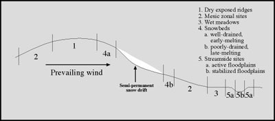
Generalized toposequences for Arctic Alaska
Mesotopic Gradient Position legend colors:
Dry exposed site
Moist site
Wet site
Snowbed, early-melting
Snowbed, late-melting
Riparian site, active
Riparian site, stable
During the making of the CAVM, a generalized toposequence was used to help organize the plant-community information from each bioclimate subzone and floristic province (Fig. 6). The table for the Alaska portion of the CAVM is presented on the back of the Alaska Arctic Vegetation Map (Raynolds et al. 2006). This table has been reformatted with short names for each plant community (Table 1) with an explanation of the naming convention for the plant communities and the organization of the table.
This information has been used to make toposequence diagrams for the Zonal toposequences in the Northern Alaska Province of the AATVM, which is currently the main focus of the Arctic Geobotanical Atlas.
More information about toposequences.
 |
|
| The University of Alaska Fairbanks is an affirmative action/equal opportunity employer and educational institution. | |
|
Loading
| |
Last modified: October 26, 2012