Alaska Arctic Detailed Map Description
- AATVM
- Vegetation
- Bioclimate Subzones
- Floristic Provinces
- AVHRR
- Elevation
- Lake Cover
- Physiography
- NDVI and Phytomass
- Substrate Chemistry
- Literature


Map extent
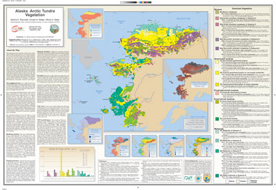
The map portrays the vegetation of the Arctic Tundra within Alaska, north and west of the forest boundary, at a scale of 1:4 million (Raynolds et al. 2005). The Arctic Tundra Bioclimate Zone is characterized by an arctic flora, an arctic climate and tundra vegetation (Elvebakk et al. 1999). It excludes areas that have a boreal flora such as the Aleutian Island and alpine tundra regions south of treeline.
Legend
The map polygon boundaries and colors follow those for the Alaska portion of the Circumpolar Arctic Vegetation Map (CAVM Team et al. 2003, Walker et al. 2005). The major difference between the CAVM and this map is a numeric suffix that has been added to each map polygon code to provide more information about the dominant plant communities. This resulted in 33 map units that refer to physiognomic groups of plant communities on specific substrates or in different geographic regions of the map. For example, the CAVM map unit S1 (Erect dwarf-shrub tundra) has been divided into four subunits: S1.1, foothills of the Eastern Brooks Range; S1.2, foothills of the western Brooks Range and Seward Peninsula; S1.3, Yukon Delta and Nunivak Island; and S1.4, foothills of the Kuskokwim Mountains. The descriptions of each of these units reference specific dominant plant communities (e.g., community 42 in map unit S1.1; community 48 and community 76 in map unit S1.2).
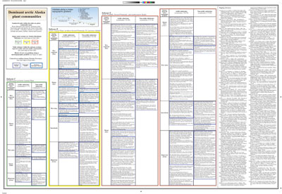
Plant community codes and descriptions on the back of the map
The descriptions of the 33 map units contain reference to 85 numbered plant communities that have been described in the different regions of the map. Table 1 contains a summary of the community codes and names organized hierarchically by:
- Bioclimate subzones (C, D, and E)
- Floristic subprovince (Northern Alaska, Beringian Alaska, and Northern Beringian Islands)
- Position of the plant community along an idealized toposequence (dry, moist, wet, snowbed, and riparian)
- Acidic vs. nonacidic substrates
Plant communities were not given formal names on the map because of the wide diversity of approaches used to name communities in the literature. Instead, each numeric code is followed by:
- The common plant functional types (growth forms) and species that were gleaned from the literature. (The dominant or characteristic plant growth forms and species are listed first.)
- Listed in smaller print are:
- The original plant community reference numbers or map codes and/or names used in the literature
- typical habitats described in the studies
- authors and dates of the studies
- locations of the studies
In several instances, the same or similar lists of plants occur with different numeric codes. This occurs because plant communities can span more than one bioclimate subzone, floristic province, or substrate type, and/or we could not find good information that would justify a unique name for the plant community.
For more information, see the expanded explanation of the plant community descriptions.
Mapping process
A 1:4 million-scale color-infrared (CIR) image of AVHRR satellite data was used as a base map. Data for each 1-km AVHRR pixel were selected at the time of maximum greenness from biweekly images from 11 July to 30 August 1993 and 1995.
Key environmental and biological factors which control plant communities in Arctic Alaska were used to determine the dominant vegetation type of a mapped polygon (Walker 1999, 2000, Walker et al. 2002). Temperature and vegetation data together define bioclimate subzones. East-west variations in species distribution were defined by floristic provinces. Bedrock geology and surficial geology were used to determine the general chemistry of the substrate on which plant communities grow. Landscape topography and lake cover are important factors affecting soil moisture available to plants. Plant biomass was estimated from the normalized difference vegetation index. All of these factors were combined to determine the dominant vegetation type of a polygon.
The minimum polygon size on the map is 14 km diameter (8 km for linear features). The dominant vegetation type of each polygon was mapped with the recognition that polygons at this scale contain many vegetation types. Some of this heterogeneity can be characterized by a topographic sequence. Typical dry, moist, wet, snowbed and riparian communities that might be inclusions within another polygon are described for each bioclimate subzone, floristic region, and acidic and nonacidic substrates. Nomenclature follows the USDA Plants Database (plants.usda.gov), with input from David Murray.


