Toolik Lake Permanent Vegetation Plots
Walker D.A. and Barry N. 1991. Toolik Lake permanent vegetation plots: site factors, soil physical and chemical properties, plant species cover, photographs, and soil descriptions. Data Report 48, Department of Energy R4D Program, Institute of Arctic and Alpine Research, University of Colorado, Boulder, CO.
Home //
Plot location map //
Preliminary vegetation classification //
Communities and microsites //
Environmental variables //
Environmental information: Abiotic data,
Biotic data //
Soils Characteristics //
Species Composition //
Selected Soil Descriptions //
Plot Photos
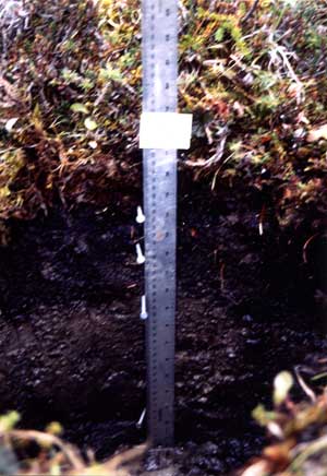
Soil Description, Plot SWT-54
|
 | | | Classification: | Histic Pergelic Cryaquoll, fine-loamy, mixed. |
|---|
| Location: | Northwest side of Toolik Lake, at base of steep north slope toposequence, between SWT-47 and SWT-58. 68°38' N, 149°38' W. |
|---|
| Physiographic position: | Lower footslope of 6 percent SSW-facing slope. |
|---|
| Topography: | Hummocky terrain, including turf hummocks and some solifluction features. |
|---|
| Microrelief Height: | 30 cm. |
|---|
| Drainage: | Somewhat poorly drained. |
|---|
| Vegetation: | Moist Eriophorum vaginatum, Salix planifolia ssp. pulchra, Hylocomium splendens, Sphagnum rubellum, tussock-sedge, dwarf-shrub tundra |
|---|
| Parent material: | Itkillik II glacial till. |
|---|
| Sampled by: | D.A. Walker and C. Westberg, August 10, 1989. |
|---|
| Remarks: | Ground frozen at 44 cm. Soil saturated below 11 cm. Minor animal disturbance. |
|---|
| Weather: | Raining. |
|---|
| Horizons: | Colors are for the wet soil. |
|---|
| Oi | 0-8 cm. Loose moss, moss bases, tussock bases and roots; pH = 4.3; wavy clear boundary. (Sample T-137). |
|---|
| Oe | 8-15 cm. Black (7.5YR 2/1) loose hemic material; est. 20 percent recognizable plant fibers after rubbing (beneath tussocks); weak moderate platy structure; pH = 6.2; coarse roots of Eriophorum vaginatum make up to 75 percent of horizon's volume; clear smooth boundary. (Sample T-138). |
|---|
| Oa | 15-21 cm. Very dark brown (7.5YR 2/3) sandy loam; dark yellowish brown (10YR 4/6) medium mottles form discontinuous band at base of Oa; weak moderate platy structure; wet; pH = 5.4; est. 20 percent recognizable plant fibers after rubbing (sedge leaves and roots); abrupt smooth boundary. (Sample T-139). |
|---|
| B | 21-39 cm. Dark brown (10YR 3.5/3) gravelly sandy clay loam; massive structure; very wet; gritty, sticky, plastic (wet); pH = 5.6; est. 15 percent fine gravel up to 2 cm diameter; gradual wavy boundary. (Sample T-140). |
|---|
| Cg | 39-44+ cm. Dark gray (10YR 4/1) gravelly sandy clay loam; massive structure; very wet; gritty, very sticky, very plastic (wet); pH = 5.0; est. 15 percent fine gravel less than 2 cm diameter. (Sample T-141). |
|---|
|
|
| Enlarge soil photo |
|


