Toolik Lake Area Releve Locations
- Toolik Area
- Vegetation
- Elevation
- SPOT
- Landforms
- Releve Locations
- Glacial Geology
- Percent Water
- Surficial Geology
- Surficial Geomorphology
- Soil Carbon
- Literature

| Available data: | ||||
| |
GE |
Metadata |
GIS data |
GIS data |
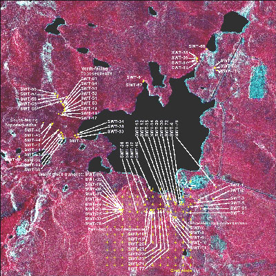
Figure 1. Vegetation study plot locations (Walker and Barry 1991)
This map shows the location of 81 study plots at the Toolik Lake research site, located in the southern Arctic Foothills of the Brooks Range, Alaska (68°37'N, 149°32'W). The data collected from these plots are summarized in Toolik Lake permanent vegetation plots: site factors, soil physical and chemical properties, plant species cover, photographs, and soil descriptions, in the Supporting Data section of the TAGA. The data report brings together for easy reference all the available information collected from the plots. This information is being used for the classification, mapping and analysis of the geobotanical factors in the Toolik Lake and Imnavait Creek region.
A reconnaissance survey was conducted in August 1988 to define the primary vegetation types in the Toolik Lake area. Unknown plants were collected and many informal partial relevés were sampled with reference to spectral signatures on a 1:50,000-scale color-infrared photograph. A total of 22 preliminary vegetation types were defined based on habitat and dominant species. Formal relevé sampling for the plots in this data report was done during the period 1-26 August 1989. An attempt was made to sample at least three relevés for each of the types defined in 1988, but this was not possible in all cases. The plots were located in homogeneous areas of vegetation using the centralized replicate method of the Braun-Blanquet approach to vegetation classification (Mueller-Dombois and Ellenberg, 1974; Westhoff and van der Maarel, 1978).
Nearly all of the plots are permanently marked. The exception is plot SWT-55. The plots are marked with 48-inch (122-cm) wooden stakes and aluminum tags at the base of the stakes with the plot numbers.
Included in the data report are Tables 1 through 6, summarizing the collected data; and two appendices, with plot and soil photos, and this plot location map. Each table includes links to a PDF and an MS Excel or MS Word file.
- Table 1, Preliminary vegetation classification based on habitat and dominant species and sample numbers for each type.
- Table 2, List of vegetation communities and microsites sampled in 1989.
- Table 3, Legend for the environmental variables.
- Table 4, Environmental data for permanent plots (divided into two tables for ease of downloading data).
- Table 5, Soils data for Toolik lake permanent plots.
- Table 6, Toolik Lake permanent plot species data.
Walker D.A. and Barry N. 1991. Toolik Lake permanent vegetation plots: site factors, soil physical and chemical properties, plant species cover, photographs, and soil descriptions. Data Report 48, Department of Energy R4D Program, Institute of Arctic and Alpine Research, University of Colorado, Boulder, CO.


