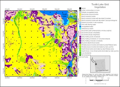
Toolik Lake Grid Vegetation
- Toolik Grid
- Vegetation
- Elevation
- Landforms
- Releve Locations
- Glacial Geology
- Percent Water
- Surficial Geology
- Surficial Geomorphology
- Hierarchy of Geobotanical Vegetation Map Units (Walker DA 2002)
| Available data: | ||||
 |
 GE |
 Metadata |
 GIS data |
 GIS data |
- Barren
 1. Anthropogenic barren.
Barren (901).
0.16 ha, 0.1% of map 2. Lichen on rock.
Cetraria nigricans-Rhizocarpon geographicum (902).
0.11 ha, 0.1% of map 3. Partially vegetated barren.
Festuca rubra (903); Salix alaxensis (904); Epilobium latifolium (905); Juncus biglumis-Luzula arctica (no code).
0.23 ha, 0.2% of map
- Moist Graminoid Tundra
 4. Tussock-sedge.
Tussock sedge, dwarf-shrub, moss tundra (tussock tundra, moist acidic tundra). Mesic to subhygric, acidic, shallow to moderate snow, stable. This unit is the zonal vegetation on fine-grained substrates with ice-rich permafrost (406, 407). Some areas on steeper slopes with solifluction are dominated by Bigelow sedge (Carex bigelowii) (404, 405).
65.92 ha, 54.2% of map 5. Nontussock-sedge.
Nontussock sedge, dwarf-shrub, moss tundra (moist nonacidic tundra). Mesic to subhygric, nonacidic (pH > 5.5), shallow to moderate snow. Solifluction areas and somewhat unstable slopes (401,403). Some south-facing slopes have scattered glaucous willow (Salix glauca) (320).
7.04 ha, 5.8% of map 6. Nontussock-sedge, horsetail.
Nontussock sedge, prostrate dwarf-shrub, horsetail, moss tundra (wetter subtypes of moist nonacidic tundra, often with abundant horsetails). Mesic to subhygric, nonacidic, moderate snow. Seepage areas below snowbeds with abundant horsetails (Equisetum arvense) (402) or aquatic sedge (C. aquatilis) in wetter areas (410).
2.22 ha, 1.8% of map 7. Nontussock-sedge, Cassiope.
Sedge, hemi-prostrate dwarf shrub, moss tundra (moist nonacidic tundra in snow accumulation areas). Mesic to subhygric, mostly nonacidic, moderate to deep snow. Inter-stripe areas in nonsorted stripe complexes on upper hill-slopes with moderate to deep snow and abundant Lapland heather (Cassiope tetragona). This unit also includes several miscellaneous graminoid, dwarf-shrub, forb communities that cover small areas, including animal dens (106), deep-snow stream and lake margins (106), dry snow accumulation areas (412) and stream banks (109).
1.64 ha, 1.3% of map
- Wet Graminoid Tundra and Water
 8. Sedge-moss tundra (poor fens).
Sedge, prostrate dwarf-shrub, moss tundra. Hygric to subhydric. Hummocks, strangs and raised microsites in fens (409) and poor fens in wet meadows and colluvial-basins (411, 508) and mossy colluvial basin margins (506).
0.32 ha, 0.3% of map 9. Sedge-moss tundra (fens).
Sedge, moss tundra in fens with flowing water. Subhydric to hydric. Lower microsites in colluvial basins, water tracks and stream margins (501, 502, 503, 505), wet pools on solifluction slopes (507).
2.30 ha, 1.9% of map 10. Unvegetated water.
Hydric. Streams, lakes, ponds.
5.34 ha, 4.4% of map 11. Herbaceous marsh.
Herbaceous marsh. Hydric. Water to 1-m deep in lakes and ponds.
0.33 ha, 0.3% of map
- Prostrate- and hemi-prostrate dwarf-shrub tundra
 12. Prostrate dwarf-shrub (acidic).
Prostrate dwarf-shrub, fruticose-lichen tundra. Xeric, acidic, shallow snow. Dry acidic tundra on well-drained glacial till, outwash and exposed sites.
5.14 ha, 4.2% of map 13. Prostrate dwarf-shrub (Dryas octopetala).
Prostrate dwarf-shrub, forb, fruticose-lichen tundra. Xeric, acidic, wind blown or shallow winter snow cover, stony or with considerable bare soil. Ridge crests, dry river terraces. Dominated by Dryas octopetala (101), occasionally with Salix glauca (102).
3.71 ha, 3.1% of map 14. Prostrate dwarf-shrub (Dryas integrifolia).
Prostrate dwarf-shrub, forb, fruticose-lichen tundra. Xeromesic to mesic, nonacidic, wind-blown to shallow winter snow cover. Dry slopes, river terraces, drier microsites in nonsorted stripe complexes, dominated by Dryas integrifolia.
0.72 ha, 0.6% of map 15. Hemi-prostrate dwarf-shrub (acidic).
Hemi-prostrate dwarf-shrub, fruticose-lichen tundra. Subxeric to mesic, acidic, moderately deep snow. Acidic snowbeds (50-150 cm snow).
2.35 ha, 1.9% of map 16. Hemi-prostrate dwarf-shrub (snowbed < 1m).
Hemi-prostrate and prostrate dwarf-shrub, forb, moss, fruticose-lichen tundra. Subxeric to mesic, acidic, shallow to moderately deep snow (<1 m deep). Nonsorted stripe complexes with shallow to moderately deep snow (104, 111).
3.54 ha, 2.9% of map 17. Hemi-prostrate dwarf-shrub (nonacidic).
Hemi-prostrate dwarf-shrub, fruticose-lichen tundra. Subxeric to mesic, nonacidic, moderately deep snow. Nonacidic snowbeds (50-150 cm snow) (113, 204, 205). Also includes deep (>3 m snow) well-drained snow-beds with Salix rotundifolia (207).
1.39 ha, 1.1% of map 18. Hemi-prostrate dwarf-shrub (warm snowbed).
Hemi-prostrate dwarf-shrub, fruticose-lichen tundra. Subxeric to mesic, acidic, moderately deep snow. Depressions on glacial till or outwash (302, 303); warm snowbeds (201). Very low-growing hemi-prostrate dwarf-birch (Betula nana) (302, 303) or erect dwarf blueberry (Vaccinium uliginosum ssp. microphyllum) (110) or Labrador tea (Ledum palustre ssp. decumbens) (201).
7.47 ha, 6.1% of map
- Erect-shrub tundra
 19. Dwarf to low-shrub (birch).
Dwarf-shrub, sedge, moss tundra (shrubby tussock tundra dominated by dwarf birch, Betula nana). Mesic to subhygric, acidic, moderate snow. Lower slopes and water-track margins. Mostly on Itkillik I surfaces.
3.75 ha, 3.1% of map 20. Dwarf to low-shrub (willow).
Dwarf-shrub, sedge, moss tundra (shrubby tussock tundra dominated by diamond-leaf willow, Salix pulchra). Subhygric, moderate snow, lower slopes with solifluction.
3.59 ha, 3.0% of map 21. Low to tall shrublands (birch).
Dwarf-shrub, moss tundra dominated by dwarf birch (Betula nana). Subhygric to hygric, acidic, moderate to moderately deep snow. Upland water tracks, margins of water tracks and lower slope areas (306, 307). Somewhat drier areas have abundant lichens (304).
2.08 ha, 1.7% of map 22. Low to tall shrublands (willow).
Dwarf-shrub or low-shrub tundra dominated by willows (Salix pulchra). Subhygric, acidic, moderate to moderately deep snow. Margins of upland water tracks, palsas and high-centered polygons.
1.36 ha, 1.1% of map 23. Low to tall shrublands (water-track).
Low shrublands (generally 40-100 cm tall). Subhydric to mesic, moderate to deep snow. Deeper upland water tracks with flowing water (314, 315) or riparian areas along major streams (316).
0.74 ha, 0.6% of map 24. Low to tall shrublands (riparian).
Tall shrublands (> 2 m tall). Subhydric to mesic, nonacidic, moderate to deep snow. Stream margins dominated by tall willows, Salix alaxensis (323, 324) and/or S. richardsonii (319).
0.21 ha, 0.2% of map
 |
|
| The University of Alaska Fairbanks is an affirmative action/equal opportunity employer and educational institution. | |
|
Loading
| |
Last modified: January 17, 2012