Upper Kuparuk River Region Landforms
- Upper Kuparuk
- Vegetation
- SPOT
- Elevation
- Hydrology
- NDVI and Phytomass
- Landforms
- Glacial Geology
- Surficial Geology
- Surficial Geomorphology
- Literature
| Available data: | ||||
 |
 GE |
 Metadata |
 GIS data |
 GIS data |
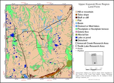
(from metadata) The landform map (elevation) of the Upper Kaparuk River region covers 751-km2 in the upper Kaparuk River watershed, including the Toolik Lake and the Imnavait Creek research areas, as well as portions of the Dalton Highway and Trans-Alaskan Pipeline from the northern end of Galbraith Lake to Slope Mountain. Elevation strongly influences temperature, soil moisture and patterns of tundra plant communities. Landforms were grouped into the following classes for map display:
- Hill or mountain: Includes undifferentiated hills and mountains of all slopes and sizes. Includes moraines and kames.
- Talus slope: Accumulation of mass-wasted boulders forming an apron below bedrock exposures.
- Bluff or cliff: Very steep slopes usually associated with bedrock areas or eroded lake and river margins.
- Flat: Undifferentiated flat areas.
- Basin: Refers primarily to colluvial basins (Kreig and Reger 1985 or Kreig and Reger 1982?), between hills usually filled with wetlands and broad watertracks.
- Drained or filled lakes: Includes drained glacial kettle lakes in outwash deposits, drained glacial moraine-damned lakes such as the ancient Lake Galbraith, and filled lakes and pond margins.
- Floodplain or floodplain terrace: Includes active and nonactive floodplains and glaciofluvial outwash, ancient floodplains, also wide drainages filled with watertracks, abandoned sloughs, point bars, oxbows, etc.
- Debris flow: Includes areas of melting ground ice with debris flows.
- Alluvial fan: Includes nearly flat alluvial fans associated with existing and ancient lakes and steep alluvial fans at the base of steep valleys that are products of debris flows.
- Lake or pond.
- Disturbed area: Includes gravel mines and gravel construction pads.
 |
|
| The University of Alaska Fairbanks is an affirmative action/equal opportunity employer and educational institution. | |
|
Loading
| |
Last modified: January 17, 2012