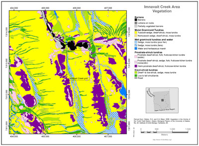
Imnavait Creek Area Vegetation
- Imnavait Area
- Vegetation
- Elevation
- SPOT
- Landforms
- Releve Locations
- Glacial Geology
- Percent Water
- Surficial Geology
- Surficial Geomorphology
- Literature
- Hierarchy of Geobotanical Vegetation Map Units (Walker DA 2002)
| Available data: | ||||
 |
 GE |
 Metadata |
 GIS data |
 GIS data |
text regarding Imnavait Creek Area Vegetation.
- Barren
 1. Unvegetated Barrens.
Unvegetated natural and anthropogenic barrens.
25.19 ha, 1.18% of map 2. Lichens on rocks.
Xeric blockfields, glacial erratics.
5.04 ha, 0.24% of map 3. Partially or sparsely vegetated.
Partially vegetated disturbed barrens on gravel pads, abandoned roads, bulldozed areas.
12.59 ha, 0.59% of map
- Moist Graminoid Tundra
 4. Moist acidic tussock tundra.
Tussock sedge, dwarf-shrub, moss tundra. Moist acidic tussock tundra complexes dominated by graminoids.
1149.51 ha, 53.73% of map 5. Moist nonacidic tundra.
Nontussock sedge, dwarf-shrub, moss tundra. Moist nonacidic tundra complexes.
19.65 ha, 0.92% of map
- Wet Graminoid Tundra and Water
 6. Poor fens.
Poor fens: Sedge, moss tundra, Nutrient-poor fen wetland complexes.
57.01 ha, 2.66% of map 7. Fens.
Fens: Sedge, moss tundra, Nutrient-rich fen wetland complexes.
112.88 ha, 5.28% of map 8. Water and herbaceous marsh.
Water and herbaceous marsh.
17.92 ha, 0.84% of map
- Prostrate- and hemi-prostrate dwarf-shrub tundra
 9. Acidic dry tundra.
Acidic dry tundra. Prostrate dwarf-shrub, fruticose-lichen tundra.
157.01 ha, 7.34% of map 10. Nonacidic dry tundra.
Dry nonacidic tundra: Prostrate dwarf-shrub, sedge, forb, fruticose-lichen tundra.
9.11 ha, 0.43% of map 11. Snowbeds.
Hemi-prostrate and prostrate dwarf-shrub, forb, moss, fruticose-lichen tundra.
Hemi-prostrate dwarf-shrub, fruticose-lichen tundra. Dry or moist shrublands with very low-growing or creeping dwarf-shrubs.
234.23 ha, 10.95% of map
- Erect-shrub tundra
 12. Dwarf-shrub tundra.
Dwarf-shrub or low-shrub, sedge, moss tundra. Moist acidic tundra complexes dominated by shrubs, including shrubby tussock tundra.
Also dwarf-shrub tundra dominated by dwarf birch or willows.
210.98 ha, 9.86% of map 13. Low and tall shrublands.
A wide variety of low to tall shrublands.
128.25 ha, 5.99% of map
 |
|
| The University of Alaska Fairbanks is an affirmative action/equal opportunity employer and educational institution. | |
|
Loading
| |
Last modified: January 17, 2012