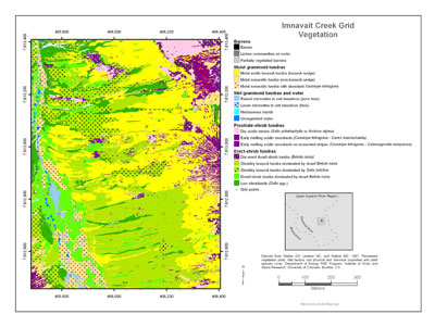
Imnavait Creek Grid Vegetation
- Imnavait Grid
- Vegetation
- Elevation
- Landforms
- Releve Locations
- Glacial Geology
- Percent Water
- Surficial Geology
- Surficial Geomorphology
- Hierarchy of Geobotanical Vegetation Map Units (Walker DA 2002)
| Available data: | ||||
 |
 GE |
 Metadata |
 GIS data |
 GIS data |
- Barren
 1. Barren.
Barren (32).
0.004 ha, 0.01% of map 2. Lichens on rocks.
Xeric blockfields, glacial erratics.
0.154 ha, 0.22% of map 3. Partially vegetated.
Partially vegetated disturbed barrens on gravel pads, bulldozed areas (33), nonsorted circles (no code), and experimental structure (34).
0.012 ha, 0.02% of map
- Moist Graminoid Tundra
 4. Acidic mesic tussock tundra.
Mesic to subhygric, acidic, shallow to moderate snow, stable slopes, Subzone E zonal vegetation on fine-grained substrates with ice-rich permafrost. Subhygric to hygric, moderate snow, solifluction slopes (10, 11).
21.541 ha, 31.25% of map 5. Other mainly nonacidic mesic tundra.
Mesic to subhygric, circumneutral to acidic, moderate to deep snow, includes inter-stripe areas nonsorted stripe complexes in areas with moderate to deep snow.
Misc. sites including deep-snow stream margins, circumneutral, some revegetated disturbed sites, and zoogenically disturbed areas, animal dens. (14, 18, 19, 25).
3.321 ha, 4.82% of map
- Wet Graminoid Tundra and Water
 6. Wet raised microsites.
Hygric to subhydric, hummocks and strangs in poor fens and fens, raised microsites in colluvial basins, colluvial basin margins (23, 24).
3.043 ha, 4.42% of map 7. Poor fen.
Subhydric to hydric, meadows, ponds, poor fens in colluvial basins (20, 28).
0.843 ha, 1.22% of map 8. Fen.
Subhydric to hydric, water tracks, stream margins, fens, flarks on solifuluction slopes (21, 22, 27, 30).
0.095 ha, 0.14% of map 9. Herbaceous marsh.
Hydric, lakes and beaded ponds (29).
0.053 ha, 0.08% of map 10. Water.
Hydric, ponds and streams (31).
0.233 ha, 0.34% of map
- Prostrate- and hemi-prostrate dwarf-shrub tundra
 11. Dry acidic tundra.
Xeric, acidic, shallow snow; glacial till, exposed sites on siliceous substrates (1, 2, 3).
Subxeric to mesic, acidic to nonacidic, shallow snowbeds, non-sorted stone stripes (4).
1.764 ha, 2.56% of map 12. Acidic Castet snowbeds.
Subxeric to mesic, acidic, moderate snowbeds (9).
0.171 ha, 0.25% of map 13. Acidic strips with Castet.
Subxeric to mesic, acidic to nonacidic, shallow snowbeds, non-sorted stone stripes (5).
3.340 ha, 4.85% of map 14. Dry hemi-prostrate Betnan.
Subxeric to mesic, acidic, shallow depressions on glacial till (6).
1.522 ha, 2.21% of map
- Erect-shrub tundra
 15. Betnan-Erivag dwarf shrub.
Mesic to subhygric, moderate snow, lower slopes (12).
15.167 ha, 22.01% of map 16. Salpul-Carbig dwarf shrub.
Subhygric, moderate snow, lower slopes with solifluction (13).
6.160 ha, 8.94% of map 17. Betnan-Rubcha dwarf shrub.
Subhygric, moderate snow, margins of upland water tracks, palsas, high-centered polygons (15).
6.210 ha, 9.01% of map 18. Low shrub tundra.
Subhygric, moderate snow, margins of upland water tracks, palsas, high-centered polygons.
Subhygric to hygric, moderate to deep snow, upland water tracks and margins of water tracks, and lower slope areas (16, 17).
4.960 ha, 7.20% of map 19. Salpul-Eriang water tracks.
Subhydric, deep snow, upland water tracks with flowing water (26).
0.330 ha, 0.48% of map
 |
|
| The University of Alaska Fairbanks is an affirmative action/equal opportunity employer and educational institution. | |
|
Loading
| |
Last modified: January 17, 2012