Circumpolar Arctic Elevation
- CAVM
- Vegetation
- About the Vegetation Map Units
- Bioclimate Subzones
- Floristic Provinces
- AVHRR
- Elevation
- Lake Cover
- Physiography
- NDVI and Phytomass
- Substrate Chemistry
- Coastline
- Literature
| Available data: | ||||
 |
 GE |
 Metadata |
 GIS data |
 GIS data |
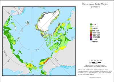
Adiabatic cooling of air masses at higher elevations causes altitudinal zonation (elevation belts). For continental areas, the environmental adiabatic lapse rate is about 6 °C per 1000 m (Barry 1981). This is equivalent to a shift in bioclimatic subzone for about every 333 m elevation gain. A topographic map was made with elevation isolines at 333, 667, 1000, 1333, 1667, and 2000 meters. These show roughly where altitudinal zonation shifts can be expected.
See also:
 |
|
| The University of Alaska Fairbanks is an affirmative action/equal opportunity employer and educational institution. | |
|
Loading
| |
Last modified: October 25, 2012