Circumpolar Arctic Vegetation Map
About the map
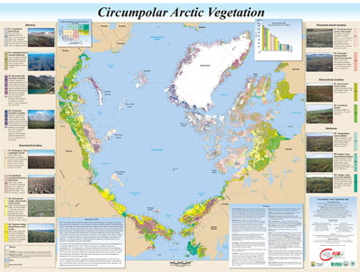
The CAVM, published at 1:7,500,000 scale, is the first vegetation map and GIS of an entire global biome at a comparable resolution. The map provides a broad view of the vegetation of the whole Arctic through legend descriptions, photographs, lists of major syntaxonomic groups, and supplementary maps. The consistent treatment of the vegetation across the circumpolar Arctic, and abundant ancillary material, make the maps and database appropriate for numerous land-use management, educational, and modeling applications. It has already helped vegetation scientists in Eurasia and North America to recognize and resolve major vegetation terminology conflicts between various regions. The digital data will make updating the map relatively easy. The final map was published at 1:7,500,000 scale map by the USFWS as CAFF Map No. 1 (CAVM Team 2003). For a full area analysis of the CAVM by bioclimate subzone and country refer to Walker et al. (2005).
Themes
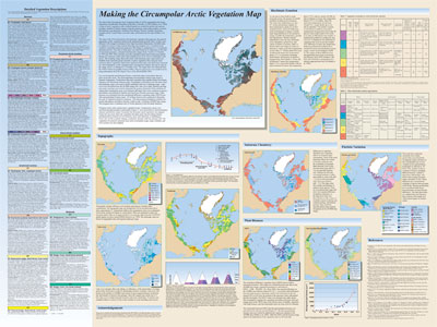
The map includes the following detailed geobotanical themes:
- Vegetation
- About the Vegetation Map Units
- Bioclimate Subzones
- Floristic Provinces
- AVHRR
- Elevation
- Lake Cover
- Physiography
- NDVI and Phytomass
- Substrate Chemistry
- Coastline
Suggested citation:
CAVM Team. 2003. Circumpolar Arctic Vegetation Map. (1:7,500,000 scale), Conservation of Arctic Flora and Fauna (CAFF) Map No. 1. U.S. Fish and Wildlife Service, Anchorage, Alaska. ISBN: 0-9767525-0-6, ISBN-13: 978-0-9767525-0-9
Purchasing the map:
To purchase the map, contact the Geophysical Institute Map Office (907.474.6960), on the University of Alaska Fairbanks campus. Map is printed on glossy paper, $15.00.